Alabama Skies: Stormy weather heading our way; severe threat upgraded
Published 9:20 pm Sunday, March 24, 2024
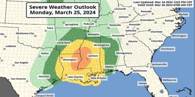
Monday night into Tuesday morning is going to quite soggy and stormy across the state. Although the worst of the weather is expected to stay towards Louisiana and Mississippi, there is a risk for some severe weather in the state. One area with potential bad weather has been upgraded to a Level 2 risk.
According to the Storm Prediction Center, western Alabama from just southwest of Fayette to Mobile is under a Level 2 risk. Communities included are Demopolis, Butler, and Saraland. In this area, tornadoes and damaging winds are possible.
A Level 1 includes much of the rest of Alabama. Strong storms are possible with the same severe risk, but with lesser confidence.
Besides the severe risk, heavy rain and strong winds are also possible.
Storms are expected to begin around 11 p.m. in the west, 3 a.m. in central Alabama, and 5 a.m. for eastern Alabama.
North Alabama
Mostly cloudy and windy with gusts up to 40 miles per hour. High of 65. Monday night, showers and thunderstorms. Low of 57.
Central Alabama
Mostly cloudy with a high of 68. Breezy with wind gusts up to 35 miles per hour. Showers and thunderstorms Monday night with a low of 57. A storm or two could be strong to severe.
South Alabama
Mostly cloudy with a high of 73 and wind gusts up to 30 miles per hour. Showers likely overnight with a couple of thunderstorms possible. A storm or two could be strong to severe. Low of 60.
Gulf Coast
Cloudy with a slight chance of a shower in the afternoon. High of 71. Wind gusts up to 40 miles per hour possible. Showers and thunderstorms are possible overnight. A few storms could be severe. Low of 69.