Alabama Skies Bulletin: Severe weather, tornadoes now likely in Alabama Wednesday
Published 4:45 pm Tuesday, April 9, 2024
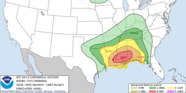
The Storm Prediction Center has now included most of Alabama in advanced risk zones for severe weather potential Wednesday.
Storms are expected by early afternoon Wednesday, continuing until midnight or so.
A Level 4 includes Tensaw, Butler, Camden, and the northern suburbs of Mobile.
“Severe storms are likely Wednesday, mainly from late morning through the evening hours,” the National Weather Service in Mobile wrote. “Destructive wind gusts up to 80 mph, tornadoes, some of which could be strong (EF2+), and large hail are possible. Have a plan and make sure you have multiple ways to receive warnings! For more information, go to our Facebook and Twitter pages or listen to NOAA Weather Radio.”
A Level 3 risk includes Demopolis, Selma, Montgomery, and Troy. Winds up to 70 miles per hour, large hail, and tornadoes are likely in this zone. The Level 2 risk includes Fayette, Birmingham, Tuscaloosa, Eufaula, and Auburn. This area includes the same risks without as much confidence.
A Level 1 cover the rest of the state. Severe storms are possible, but not as likely.


