Frigid air headed south, large swathe of Alabama under freeze threat
Published 4:32 pm Monday, October 17, 2022
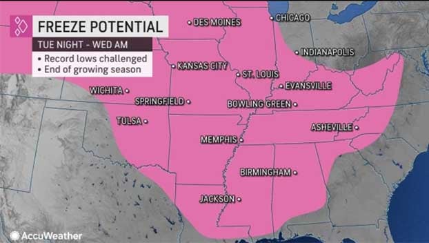
The coldest air of the season has the South in its sights and near-freezing temperatures could set new record lows across a wide swath of the region.
AccuWeather meteorologists are tracking a powerful disturbance as it sweeps through the central and eastern United States. While this storm brings the first snowflakes of the season to parts of the Midwest and Northeast, areas farther south will be in line for a dose of cold air that some may not be accustomed to handling so early in the season.
“A shot of unseasonably cold air is headed for the mid-South early this week. Overnight lows are expected to be near- to below-freezing Tuesday and Wednesday nights,” summarized AccuWeather Meteorologist Joe Curtis.
The period from Tuesday through Thursday morning looks to be the most frigid in the South as residents of Nashville, Tennessee, and Birmingham, Alabama, will wake up to lows near or just below freezing each day.
On Tuesday, a cold front will dive farther southward and cooler weather will arrive along much of the Gulf coast from the Florida Panhandle to far eastern Texas. However, the most significant blast of chilly Canadian air will remain a bit farther inland and away from the warmer water of the Gulf of Mexico which will temper the extreme chill closer to the coast.
This round of wintry temperatures will be noteworthy for taking place so soon after a stretch of exceptional heat that blazed across some of the very same parts of the country around this time last month. Dozens of locations may challenge daily record lows in the upcoming mornings.
“To put this into perspective, many of these places had record-high temperatures in the upper 90s and lower 100s just under a month ago,” added Curtis.
Indeed, Nashville set new daily record highs of 99 and 100 on Sept. 20 and 21, with the latter becoming that city’s latest 100-degree Fahrenheit day on record by a full 10 days.
As the front progresses, the core of the winterlike chill will take a bit longer to press farther south into cities like Jackson, Mississippi, and Baton Rouge, Louisiana, but both of those cities will approach their daily record lows in the lower to middle 30s by Wednesday morning.
Closer to the Gulf Coast, in cities such as Mobile, Alabama, and Tallahassee, Florida, warm waters will help moderate the air by a few degrees, and temperatures are likely to remain above the freezing mark as a result. However, low temperatures in the mid to upper 30s are currently forecast for both cities, which could threaten daily record lows in both locations.
The freezing temperatures could come at a price as any late-season crops risk being damaged, especially in areas where farmers are simply not used to having to protect their crops from a freeze at this point in the year, according to AccuWeather meteorologists. Anyone on the fringes of the freezing temperatures with sensitive outdoor vegetation may also want to take precautions during this event, such as covering plants or bringing them indoors if possible.
As the broad disturbance lifts into Canada and the front pushes well off the coast, high pressure will build into the regions and temperatures will rebound several degrees by Thursday. High temperatures should then rise close to average for many by Friday.
By La Troy Thornton, Accuweather