Severe weather risk map looks like bullseye over Alabama with high chance of tornadoes
Published 4:01 pm Wednesday, March 17, 2021
A dangerous weather system capable of packing damaging storms and spawning violent, long-track tornados is taking aim on Alabama, weather forecasters say.
The risk doesn’t get much worse than what’s predicted for this afternoon and tonight, the latest forecast from the Storm Prediction Center shows.
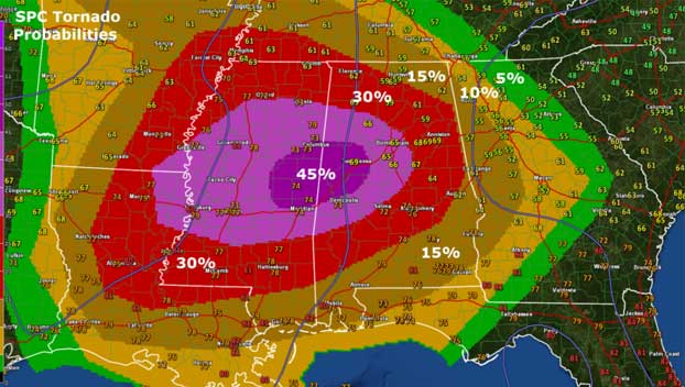
The SPC predicts a 45% hatched tornado risk area across a portion of the Mississippi-Alabama state line with an additional large swath of the state in 30% and 15% risk areas.
The percentage refers to the possibility that a tornado will pass within 25 miles of any point in that risk area. The highest percentage the SPC will issue on a same-day outlook is 60%.
The “hatched” refers to the threat for significant EF2 or greater tornadoes. Nearly all of Alabama is in the hatched risk area. You can see it on the main SPC tornado probability graphic.
Storm chasers were reporting on social media Wednesday afternoon funnel clouds spotted in western Alabama near Cuba and Thomasville
Please stay weather-aware throughout the storm event.