Hurricane warnings in effect along Gulf Coast as Zeta approaches
Published 1:19 pm Tuesday, October 27, 2020
Zeta, the 27th named storm of the 2020 hurricane season, is expected to emerge over the warm waters of the Gulf of Mexico on Tuesday, where it will intensify back into hurricane-force before it crashes into Louisiana, near Houma, which is southeast of Morgan City, late Wednesday. Forecasters have rated Zeta a 1 on the AccuWeather RealImpact™ Scale at the time of landfall. The state is bracing for its fifth strike from a named storm of the season, which will make the United States tally for land-falling storms climb to 11 — a record for the country.
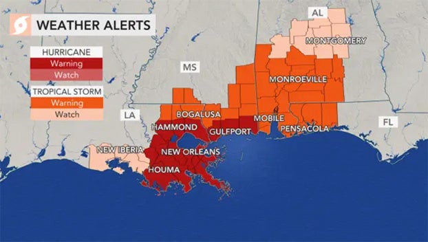
Hurricane warnings were in effect along the Gulf Coast from central Louisiana eastward to the Mississippi/Alabama border. New Orleans, which has been spared the worst from storms striking Louisiana so far this year, was included in the area under hurricane warnings.
Zeta made its first landfall as a Category 1 hurricane, packing 80-mph winds, along the coast of the Yucatan Peninsula of Mexico just north of Tulum shortly after 11 p.m. CDT Monday. The storm lost some wind intensity once over land and weakened into a tropical storm as it spun northward unleashing storm surge, heavy rain and strong winds overnight. The storm’s maximum sustained winds were 70 mph as it neared the northern coast of the Yucatan Peninsula on Tuesday morning.
There is the chance that Zeta could reach Category 2 hurricane strength (winds of 96-110 mph) as it moves over the warm waters of the Gulf Tuesday and Tuesday night, but then it could weaken slightly into a Category 1 storm (74-95 mph) before it nears the Gulf Coast on Wednesday.
“We anticipate a slight loss of wind intensity shortly before landfall on Wednesday evening, which may cause Zeta to be a minimal Category 1 hurricane or a strong tropical storm at the time of landfall,” AccuWeather Senior Meteorologist Adam Douty said.
“Regardless of this small difference of strength, overall impacts are expected to remain the same,” Douty said.
Dangerous and damaging storm surge, high winds and flooding rainfall will hammer Louisiana to Florida as Zeta makes landfall late Wednesday and begins to move inland. Several tornadoes could also touch down as the Zeta batters the U.S. Gulf Coast, especially near and east of where the storm comes onshore.
Zeta is forecast to track northeastward toward the coastline, striking just southeast of Morgan City, Louisiana, during Wednesday evening, and forecasters say the center of the storm will come close to New Orleans. The storm’s projected path has the potential to bring the most significant impacts in southeastern Louisiana and the New Orleans area of any tropical system this season as the city managed to avoid the core of all tropical systems thus far this year. The Big Easy is at risk for power outages and flooding from Zeta — and conditions will deteriorate quickly there late Wednesday.
A storm surge of 3-6 feet is forecast along the southeastern Louisiana coast, including along lakes Borgne and Pontchartrain. But, a storm surge of 1-3 feet can occur as far to the east as the northern Gulf coast of Florida and as far to the west as Intercoastal City, Louisiana.
As Zeta moves over the northern Gulf, it is expected to pick up forward speed and move along at a breakneck pace of 25 mph as it reaches the Louisiana coastline. The storm’s fast movement will likely lead to a fast rise in coastal waters —much faster than what would be expected by a system moving at a more typical speed of 10 mph.
However, the storm’s quick movement will also mean a shorter duration of high winds and torrential rainfall. Significant power outages and tree damage are still anticipated in southeastern Louisiana to part of southern Mississippi with gusts frequenting 60-80 mph. An AccuWeather Local StormMax™ of 90 mph is forecast in southeastern Louisiana.
“Power outages could last for a few days to a week in some areas and minor structural damage is expected as well, especially to weak and poorly built buildings,” Douty said.
Sporadic tree damage and power outages can occur with wind gusts of 40-60 mph as far to the north as the mid-Atlantic coast.
The central and eastern Gulf is being warned to closely monitor the progress of Zeta as the area will bear the brunt of the tropical system’s impacts, but effects will also reach far inland across the U.S.
Enough rain to cause flash and urban flooding is forecast as far to the north as the Ohio Valley, central and southern Appalachians and the mid-Atlantic coasts. Torrential rainfall will be limited to several hours due to the fast forward motion of Zeta, but downpours and moderate rainfall will precede the storm many hours in advance.
“Heavy rain is by far going to be the most widespread impact from Zeta in the United States,” warned AccuWeather Meteorologist Niki LoBiondo.
Rainfall on the order of 4-8 inches will occur along the path of Zeta as it interacts with a non-tropical storm, the same one bringing heavy snow and ice to the southern Plains and Rockies. An AccuWeather Local StormMax™ of 12 inches is forecast from southeastern Louisiana to part of western Alabama, which will be closest to the source of tropical moisture from the Gulf of Mexico.
“Flash flooding will be a threat across much of the area where the heaviest rain totals are expected, especially in places with steeper terrain,” according to AccuWeather Meteorologist Jake Sojda. “Ponding on roads and in poor drainage areas will likely be widespread, especially in communities where falling leaves clog storm drains.”
Due to the widespread nature of heavy rain over the lower Mississippi and Ohio valleys, some minor river flooding may also develop along the tributaries of these major rivers by the end of the week.
Zeta’s legacy may include tornado outbreak
Sometimes, when tropical storms or hurricanes make landfall, tornadoes and waterspouts can occur, and that will be a threat when Zeta comes ashore on the Gulf Coast.
“Tornadoes to the east of Zeta’s track can lead to localized areas of more intense damage,” Douty said. “There is the concern that there could be a higher-than-usual number of tornadoes with this tropical system as extra energy from the non-tropical storm system over the southern Plains interacts with Zeta as it moves inland.”
‘We’re doing everything we can to prepare for this storm’
Even though Zeta is expected to strike the U.S coast as a Category 1 hurricane, forecasters and officials have been warning residents along the central and eastern Gulf Coast not to let their guard down.
Louisiana Gov. John Bel Edwards declared a state of emergency on Monday ahead of Zeta’s arrival. “[The] good thing and the bad thing is we’ve had a lot of practice” at weathering storms this season, Edwards said during a Monday afternoon update on the looming threat for his state. “We’re doing everything we can to prepare for this storm,” he added.
Nearly 3,600 people remain sheltered by the state after devastating back-to-back hurricane strikes. Laura struck the state as a devastating Category 4 storm in late August, and then just 43 days later, Category 2 Hurricane Delta made landfall only 13 miles to the east of where Laura hit.