Storm system headed to Alabama brings severe weather concerns
Published 8:14 am Tuesday, February 4, 2020

By Brandon Buckingham, AccuWeather Meteorologist
A storm system that is expected to bring impactful weather to every corner of the country will bring a threat for severe thunderstorms across the South in the coming days.
Along its path, feet of snow fell across the Northwest and central Rockies while damaging wind gusts swept across Southern California and the Southwest. In addition to the severe weather threat, accumulating snow is expected on the back side of the storm system across the southern Plains, Midwest and Great Lakes.
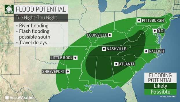
A powerful wave of energy in the upper levels of the atmosphere will act as a driving force for an expansive area of heavy rain that is expected across much of the Mississippi and Ohio River valleys through midweek.
In the lower levels of the atmosphere, warm, moist and unstable air surging northward out of the Gulf of Mexico will act as fuel for potential thunderstorm growth.
Prior to the arrival of wet weather, many locales across the South will experience springlike warmth, with temperatures in the 70s and dew points in the lower to middle 60s.
Because the threat for severe thunderstorms spans multiple days, residents in many major southern metro areas will need to remain alert this week for the potential of rapidly changing conditions.
Tuesday into Tuesday night:
Showers and thunderstorms are expected to blossom across eastern Texas and Oklahoma prior to sunrise as an area of surface low pressure develops and intensifies in the area.
As the day progresses, showers and thunderstorms are expected to track eastward into Louisiana, Arkansas and Mississippi. While doing so, a more favorable atmospheric setup in place across this area could support a few isolated strong to possibly severe thunderstorms.
Out of the three-day thunderstorm threat Tuesday through Thursday, Tuesday will likely feature the most marginal threat for severe weather. With that being said, however, it only takes one feisty thunderstorm to produce a plethora of problems.
The main hazards from thunderstorm activity Tuesday will come in the form of strong wind gusts, hail and torrential downpours. Cities at risk include El Dorado, Arkansas; Monroe, Louisiana, and Greenville, Mississippi.
What may end up being a higher threat for impactful weather Tuesday into Tuesday night will be the moderate to heavy rain across the mid-South, including much of Tennessee and Kentucky.
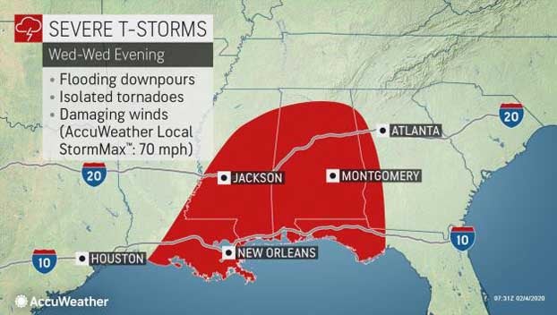
Wednesday into Wednesday night
From Wednesday into Wednesday night, atmospheric ingredients are expected to become more favorable for robust thunderstorm development as the storm system slides eastward into the Deep South. A strengthening area of low pressure will also add an extra spin in the lowest levels of the atmosphere, which may end up producing more thunderstorms that contain a rotating updraft.
Thunderstorms that contain rotating updrafts are usually able to survive longer than an average thunderstorm and they also tend to produce more severe weather reports.
“Wednesday afternoon, expect storms to initiate across southern Louisiana, Mississippi, and much of Alabama,” AccuWeather Storm Warning Meteorologist Michaela Heeren said. “Multiple waves of storms will progress across the affected areas,” she added.
Unfortunately across this region, these potentially robust thunderstorms could produce hail, damaging wind gusts and even a few tornadoes.
On top of the threat for severe weather, multiple rounds of showers and thunderstorms will lead to a heightened threat for flash flooding across the Deep South and central Gulf Coast.
Cities at risk Wednesday into Wednesday night include Mobile, Montgomery and Birmingham, Alabama; New Orleans and even Pensacola, Florida.
That thunderstorm activity will likely continue overnight Wednesday right into the daytime on Thursday. As the parent storm system continues to mature, severe thunderstorms are expected once again. While Wednesday suggests a more favorable environment for individual storms or storm clusters, Thursday will likely feature a different storm mode.
“Storms will continue to progress eastward as a cold front moves rapidly through northern Florida, Georgia, and the Carolinas,” Heeren said.
As the anticipated cold front tracks eastward, thunderstorms are expected to consolidate in a linear fashion during the afternoon hours. As they do so, damaging straight-line winds may become the primary threat from the thunderstorm activity. Along with the wind threat, flash flooding, hail and even an isolated tornado or two cannot be ruled out.
The line of powerful thunderstorms is expected to track right to the Atlantic coast by Thursday night. Major cities such as Charleston, South Carolina; Savannah, Georgia, and Jacksonville, Florida, could experience the line of thunderstorms at night.
In the immediate wake of the thunderstorm activity across the South, a powerful cold front will sweep in, ushering in a much colder air mass. Temperatures that are expected to be in the 70s prior to thunderstorm activity across the South will be replaced with 30s and 40s for a time late week.
Portions of the mid-South and possibly a few spots in extreme northern Mississippi, Alabama, and Georgia, could have rain transition over to a few wet snowflakes Thursday night before dry air moves in. If that does happen, little to no accumulation is expected.
Aside from an early morning shower or thunderstorm in South Florida on Friday, the southern and southeastern states can expect dry and cool conditions in the wake of the departed storm system.