Torrential rain, damaging winds headed to Alabama in afternoon, evening
Published 6:10 am Monday, December 16, 2019
By Maura Kelly, AccuWeather meteorologist
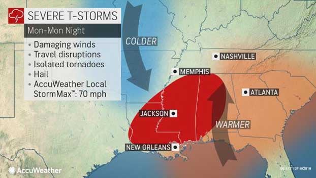
A system sweeping across the Mississippi Valley early this week will threaten parts of the Deep South with severe thunderstorms.
The storm moving out of the Rocky Mountains in the coming days will occur in two parts.
The first wave will bring wintry conditions to the central Plains and Ohio Valley on Sunday and Sunday night.
The second part will organize into a potent storm system over the Mississippi Valley on Monday.
This system will pull warm, moist air north from the Gulf of Mexico into the Deep South. At the same time, an area of high pressure will quickly build into the Plains behind this system, dragging cold air south from Canada.
The clash of these air masses will create unsettled conditions across the lower Mississippi Valley.
Through the morning hours, showers and thunderstorms are forecast to develop along a cold front sweeping through the area.
Storms are expected to strengthen into the afternoon and evening hours, becoming strong and even severe.
The strongest storms look to develop in western Tennessee, western Arkansas, Louisiana, Mississippi and Alabama and will threaten Nashville and Memphis, Tennessee, as well as Jackson, Mississippi.
“These storms will be capable of producing damaging wind gusts, torrential downpours, hail and even an isolated tornado or two,” said AccuWeather Meteorologist Brandon Buckingham. “These threats will continue for a time into the evening hours, becoming even more dangerous in the dark.”
“Travelers on interstates 20, 22, 40, 55 and others in the area should plan for rapidly changing conditions along their route as these storms track eastward,” he said.
Even in the absence of stronger storms, plenty of moisture across the region can lead to downpours.
“Any thunderstorms can produce torrential downpours which could sharply reduce visibility,” AccuWeather Meteorologist Brett Edwards said.
Motorists should also be wary of ponding on roads and the risk of hydroplaning.
Most storms are forecast to gradually weaken late on Monday night as the front continues to push to the east.
“Once the threat for thunderstorms track eastward through the overnight hours, cold air will rush in behind the passage of a cold front,” Buckingham said.
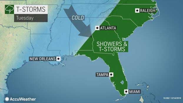
Showers and thunderstorms will shift into the Southeast on Tuesday where the environment will be less conducive for severe weather. However, storms may still produce periods of heavy rain and gusty winds.
Temperatures will be well below average on Tuesday morning into Wednesday across the lower Mississippi Valley and much of the South in the wake of the front.


