Tropical Storm Nestor forms, looks to target Florida; portions of Alabama to get rain
Published 2:35 pm Friday, October 18, 2019
By Alex Sosnowski, AccuWeather senior meteorologist
Tropical Storm Nestor formed Friday over the central Gulf of Mexico and has officials in the southeastern United States on alert as forecasters warn the system could trigger dangerous storm surge flooding, damaging winds and heavy rain.
Nestor, was traveling quickly northeastward over the Gulf on Friday, cruising along at 22 mph. By late morning, the system’s maximum sustained winds had increased to 60 mph and by Friday afternoon it was located about 195 miles south-southwest of the mouth of the Mississippi River.
Nestor was upgraded to a tropical storm at 1:35 p.m. by the National Hurricane Center.
Though sustained wind speeds were well above tropical storm force and just 14 mph shy of hurricane force, the National Hurricane Center had yet to give the storm a name as of late Friday morning, leading some AccuWeather meteorologists to speculate that because NOAA’s team of hurricane hunters, which investigated the storm on Friday, were unable to find a closed circulation, or center, the agency initially stopped short of classifying it as a tropical storm.
Nestor will continue to fight with dry air and wind shear, which along with its accelerating forward speed, should prevent the storm from becoming a powerful hurricane before making landfall.
But AccuWeather’s Chief Hurricane Expert Dan Kottlowski said that tropical development can occur anytime into Saturday. Current forecasts project that the center of this feature, whether tropical, subtropical or non-tropical in nature, will head toward the Florida Panhandle and make landfall sometime early Saturday morning.
The National Hurricane Center began issuing advisories for Potential Tropical Cyclone Sixteen on Thursday morning due to the system becoming more organized. Tropical storm warnings are in effect for portions of the northern Gulf Coast of the United States, from the Mississippi-Alabama state border to Yankeetown, Florida.
A storm surge warning has been issued for the Florida Panhandle and northwestern Florida.
Florida Gov. Ron DeSantis said on Twitter Thursday that state officials were closely monitoring the developing system and urged residents to prepare now for the chance of flooding and power disruption.
New Orleans Mayor LaToya Cantrell issued a state of emergency declaration on Thursday as a result of the storm’s projected impacts in addition to lingering issues from last week’s deadly collapse of a hotel that was under construction near the city’s French Quarter.
City officials are working to demolish two unstable two cranes at the site of the Hard Rock hotel collapse, which killed three people and injured more than 20 people on Saturday, Oct. 12. According to the Associated Press, officials will demolish the cranes with a “series of controlled explosions that would drop them straight down without damaging gas and electricity lines and historic buildings.”
Cantrell said on Twitter that officials were working to remove the cranes ahead of the arrival of tropical-storm-force winds, and there will be a larger temporary evacuation zone when the controlled demolition is scheduled.
Significant wind shear and dry air blown into the storm from the west may be the only factors that prevent the system from rapidly developing into a strong tropical storm or hurricane before it reaches the United States.
Strong winds from the west and southwest aloft will force the storm to move along at a swift pace and limit its exposure to warm waters of the Gulf of Mexico.
The storm is then likely to continue to move northeastward across southern Georgia and then along the South Carolina and North Carolina coasts over the weekend.
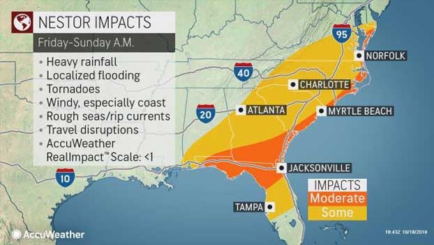
The rating for this system on the AccuWeather RealImpact™ Scale for Hurricanes is less than 1 and will be focused along the Florida Panhandle. The AccuWeather RealImpact™ Scale for Hurricanes ranges from values of less than 1 to 5.
“This system has the potential to bring heavy rainfall, damaging winds and a coastal storm surge to parts of the Florida Panhandle and northwestern Florida during Saturday morning,” Kottlowski said.
In terms of economic impacts to the region, AccuWeather Founder and CEO Dr. Joel N. Myers said, “No significant overall economic impact is expected,” from the storm, but he added, “There will be some brief economic impact where heavy rains and coastal flooding occurs.”
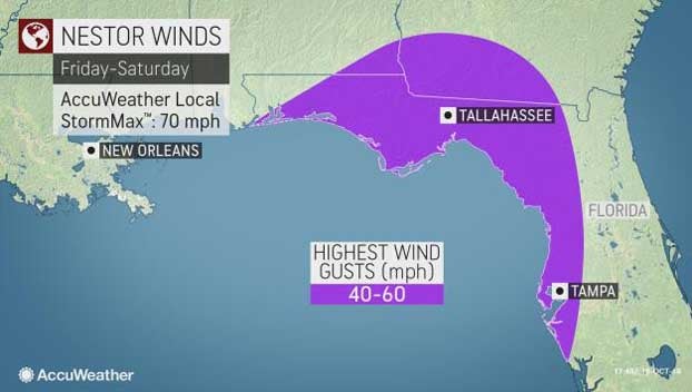
Near and north and east of the center, from late Friday to early Saturday, winds may gust in the neighborhood of 40 to 60 mph. Isolated tornadoes can also occur on the northeastern side of the storm.
As the storm moves swiftly along, strong gusts are likely along the Carolina and Virginia coasts form Saturday to early Sunday.
Similarly, a storm surge of several feet is possible, due in large part to the shape of the coastline in the area. This part of the Florida coast tends to trap and funnel water inland during approaching storms.
While these conditions will be highly dependent on the strength and exact track of the storm, the storm does not have to be tropical in nature for significant impact to occur.
Seas and surf will build over much of the Gulf of Mexico into the weekend with the most significant increase in waves and frequency and strength of rip currents throughout the Florida Gulf coast.
Small craft should consider remaining in port from Friday to Saturday over the northeastern Gulf of Mexico and during the day Saturday along the Atlantic coast from northeastern Florida to the Virginia capes. Sunday should bring much better boating, fishing and bathing conditions.
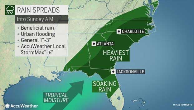
Drenching rain and localized flooding will be the main impact from the storm as it moves along over the Southeastern states.
Rain and gusty winds will make viewing and playing in football games in the Southeast difficult. However, lightning is also a threat from the storm system and could delay some games.
“During autumn, a lot of the rainfall these states typically get are from tropical systems,” AccuWeather Meteorologist Courtney Travis said. “With a lack of persistent land-falling storms, much of the region is in a drought.”
Urban flooding can occur even though much of the Southeast states could stand more rain due to the ongoing drought conditions.
A general 1-3 inches of rain is forecast from the northeastern Gulf coast to near the mouth of the Chesapeake Bay. An AccuWeather Local StormMax™ of 6 inches is most likely along the upper Gulf coast of Florida and perhaps along the North Carolina coast.
A storm earlier this week brought much of the region soaking rain, but more rain is needed to make up for the deficit. The rain is coming too late for some agricultural interests and could inhibit harvest in some cases including cotton.
During early next week, the feature is forecast to move well off the mid-Atlantic coast but has a chance of being captured and pulled toward New England as a non-tropical storm approaches from the Midwest.
The Atlantic hurricane season officially continues through the end of November.
As of Wednesday, Oct. 16, there have been 15 tropical depressions, 13 tropical storms, five hurricanes and three major hurricanes in the 2019 Atlantic hurricane season.
AccuWeather’s prediction for the 2019 Atlantic hurricane season, issued in April, was for 12-14 tropical storms, five to seven hurricanes and two to four major hurricanes.
“In terms of the long-range outlook for the Atlantic Basin, there may be signifiant inhibiting factors for tropical development during the latter part of October into early November,” Kottlowski said.
“It is possible that tropical activity effectively shuts down after the Gulf of Mexico system this week,” he added.
While this system is not expected to cause extreme damage, localized moderate damage is predicted as impacts such as coastal flooding will unfold. People should stay alert to the latest on the storm’s strength and projected track. Meanwhile, AccuWeather meteorologists say there is very little chance of this storm evolving into a significant hurricane.